Katahdin – “The Greatest Mountain” – so named by the Penobscot Indians, and deservedly so. Katahdin, both Baxter and Hamlin peaks, along with North Brother were the last on our list of the New England 67 four-thousand foot summits. It was a commitment from the start – a five hour drive from Boston, accommodations in the area, a few days of hiking, and a prayer for good weather.
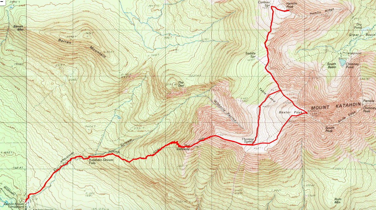
Our planned hike started at Katahdin Stream campground – one of the controlled parking areas in Baxter State Park – and followed the Hunt trail to Baxter Peak, Saddle Trail to Hamlin Peak, with a return on the Baxter cutoff and down Hunt Trail to the campground, capturing both Baxter and Hamlin peaks in a single outing, leaving North Brother on another day. We decided on the more challenging first – Baxter and Hamlin. At a book distance of 15+ miles, it was going to be a long day, no doubt. Fortunately for us, our plan was to hike mid-week, so we did not have to deal with getting shut out of our first-choice hike route, but we made reservations for each of the days to have some flexibility in the event the weather didn’t cooperate.
We were blessed with the good weather alright… Days in advance, it looked like a strong high pressure area was moving in to settle over Maine, bringing with it clear skies and temps in the 80’s. Beautiful days to be out in the woods and on the mountains.
Arriving at the gatehouse at 6:45am, we were surprised to see a line of 15+ cars, slowly making their way into the park before the 7:05am reserved-parking cutoff. After Another 45 minute dirt-road drive to the trail head, we were on the trail by 8am. The first mile or so was a refreshing walk in the woods, a gradual incline and excellent footing. Shortly afterward, we approached the Katahdin Stream Falls as the trail become more steep and littered with larger rocks.
Steep and rocky continued for a few miles until we apprached the first significant bolder scramble, with required some hand-over-hand and included a few metal bars in the rocks. And it was here that Peter rolled/sprained his ankle, mis-stepping between rocks. Fortunately not bad enough to abandon the day, though enough to slow us down a bit.
Summiting the first plateau at 5.2 miles, the land flattened out significantly and became more alpine-like – similar to sections of Crawford path on Mt. Washington. Called “Table Land”, here we saw more people, some approaching from the Abol campground, others who had been ahaed of us on the trail – but at this point, Baxter summit was visible a mile in the distance, with another bolder scramble before the summit itself.
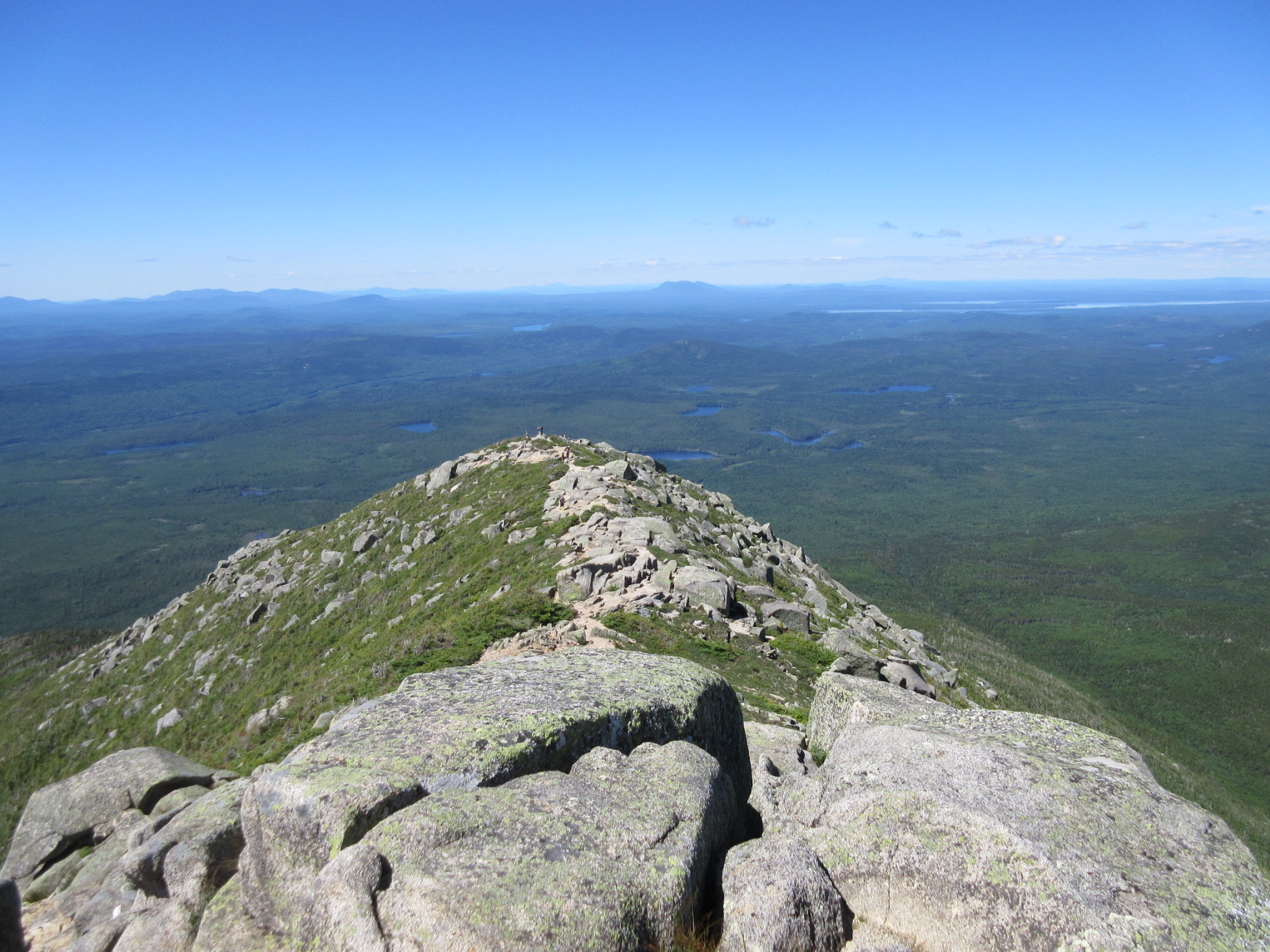
We arrived at the summit around 12:30ish, and took a few of the obligatory pictures, though the crowd of maybe 30 people made it difficult to get photos without someone in the background. The views were stunning – visibility nearly limitless in all directions, and some amazing views deep into the glacial cirque itself.

A bit of lunch, and we set off on the Saddle Trail to Hamlin Peak – roughly 2 miles to the north. A relatively gradual descent, though dicey because of the scree field, we passed the Saddle Trail junction and continued on the Northwest Basis trail to Hamlin, seeing only a few hikers along the way. Hamlin peak seemed something of a let-down, relatively non-descript, and without any sort of official signage.
It was 2 hours since we’d originally arrived at Baxter Peak, and it was at this point that we began to realize we were running out of time – we still had nearly 8 miles (and some big bolder fields!) to cover, we were moving slowly because of the ankle, and we had only about 6 hours before the park gate closed at 8:30pm. Time to get moving!
We arrived back at the height of land – the end of “Table Land” (with more stunning views) – and began our descent through the bolder field. Going down was relatively easier, crab-walking and sliding on our behinds more than a few times, we were able to descend relatively quickly. By this time, our quads were scream, so it was slow going through the few miles rock hopping descent, before we passed the falls and began the last mile of gradual woods-walking. Here is where we really picked up the pace, driven by visions of sleeping in the car if we missed the gate closing, and so much so that when passing a few other hikers, they though they were being overtaken by a moose on the trail (did we really approach that loudly?!).
We arrived at the car, now the only car remaining in the lot, just 12 hours after we’d started, at 8pm. Tossing the daypacks into the back, we bolted for the gate, taking ample liberty with speed limits, but making the gate with only a few minutes to spare.
A truly amazing hike, with some stunning views. The longest we’ve ever been on the trail in a single day – 12 hours to cover about 16 miles (our Paintbrush Divide hike in the Tetons, while longer at 19 miles, took only 9 hours). Definitely a memorable hike all around.
65 and 66 in our list of 67 – only one to go!

Comments